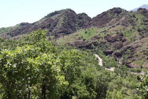
Makhmal Kuh, literary meaning velvet mountain, is an eye-catching and popular mount that dominates Khorramabad, the capital of Lorestan province, western Iran. This beautiful area is located to the north of Khoram Abad, in the valley of Makhmal Kooh. It is so called due to abundance of small stones and flowers in the way to the same.
Also known as: Tangeh Shabikhoun, Makhmal-kooh, Tang Shabikhon, Makhmal Kooh Recreational Place
Makhmal Kuh, literary meaning velvet mountain, is an eye-catching and popular mount that dominates Khorramabad, the capital of Lorestan province, western Iran. This beautiful area is located to the north of Khoram Abad, in the valley of Makhmal Kooh. It is so called due to abundance of small stones and flowers in the way to the same.
Makhmal Kuh, literary meaning velvet mountain, is an eye-catching and popular mount that dominates Khorramabad, the capital of Lorestan province, western Iran. This beautiful area is located to the north of Khoram Abad, in the valley of Makhmal Kooh. It is so called due to abundance of small stones and flowers in the way to the same.
Makhmal Kuh is a chain of mountains in Luristan measuring 2900 meters at its highest point. It is in northeastern Khorramabad. As part of the Khaydalou valley, this chain of mountains houses part of the city of Khorramabad in its foothills. Makhmal Kuh has a sedimentary texture and most of it is covered by moss and lichen. With the start of the rainy season, these grow on parts of the mountains where there is less sunshine and multiply into a green and black velvety texture.
Makhmal means Velvet in Persian. The name “velvet” comes from what the natural scenery induces its passersby to think about, “A foothill beneath velvet blankets”!
Such conception stems from the fact that Makhmal Kuh, which has a sedimentary texture, is heavily dominated with lichen and moss that range from green to black colors.
Khorramabad lies in the mountainous area of Zagross, and this region experiences a temperate climate, where as in the south alongside the plains of Khuzestan it is warm. Khorramabad (Khorram Abaad) is situated 494 km. from Tehran.
The territory of Khoram Abad has a rich ...
Falak-ol-Aflak castle (in Khorram abad) is amongst the most important structures built during the Sassanid era. It has been known by a number of names since it ...
Kaldar cave located near Khorramabad city in the western Iranian province of Lorestan. During the exploration of the Kaldar cave in Khorramabad valley by the Sefidkuh ...
Shapuri Bridge or Broken Bridge is a historical bridge from Sassanid era located in the south of Khorramabad in Lorestan province. The bridge has 28 arches (of ...
Kiu Lake (Keeyow or Kiaw) is situated alongside a park by the same name. The Keeyow Lake gains its water from the natural springs, in addition to the beauty it ...
This long and large river Seimareh, which is called Karkheh in the lower part, flows through the eastern margin of the province. Its main streams are Gamasiab, ...
This palace (museum) is one of the historical structures related to the Sassanian era. The said is located on a hill in the midst of the city of Khoram Abad. A ...
The province of West Azarbayjan has the largest lake of Iran in its territory, known as Lake Orumieh. This lake is at an altitude of 1,267 m. from the sea level, ...
Taq-e Bostan series near Kermanshah is one of the unprecedented historical monuments in Iran and the world which is the first stone animation in the world with ...
One of the best Tehran's Outdoor Experience: The beautiful nature of the strait includes the twin Waterfall which is a walkway to enjoy fresh nature for both local ...
Tandis-ha valley, meaning the valley of statues, and its surrounding located at Salakh rural district along the northern coastline of Qeshm Island in Persian Gulf, ...
The largest pedestrian overpass built in Tehran, The 270-metre (890 ft) bridge connects two public parks: Taleghani Park and Abo-Atash Park by spanning Modarres ...
let the kindness and spirit of the people draw you in! Iranian are some of the most genuinely hospitable people youve ever met. They never want anything in return, they just want to show you a good time and hope that you'll spread the word back home that Iran is a safe place to visit. Read More
 near Khorramabad in Khorramabad")
 near Khorramabad in Khorramabad")
 Fullscreen Map
 near Khorramabad")
 near Khorramabad")
 near Khorramabad")
 near Khorramabad")
 near Khorramabad")
 near Khorramabad")
 near Khorramabad")
 near Khorramabad")
 near Khorramabad")
 near Khorramabad")
 near Khorramabad")


 Loading... Please wait


 near Khorramabad")
 near Khorramabad")
 near Khorramabad")
 near Khorramabad")
 near Khorramabad")
 near Khorramabad")
 near Khorramabad")
 near Khorramabad")
 near Khorramabad")
 near Khorramabad")
 in Khorramabad")


 in Qeshm Island")

 Please wait