Behistun Inscription

Behistun Inscription - Kermanshah Province
+16 More Photos
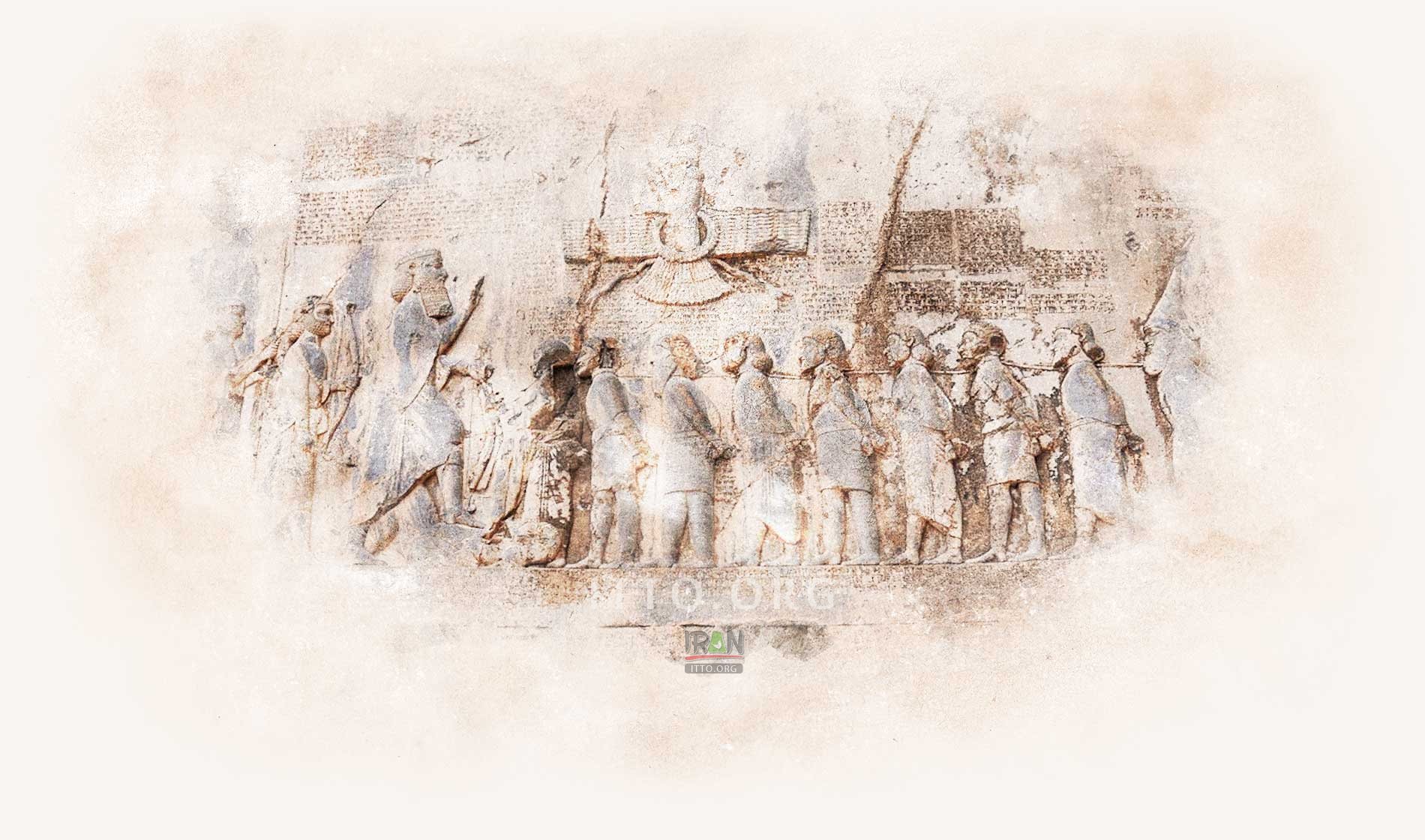
The Behistun Inscription is an engraving located on the cliff of Mount Behistun near Kermanshah (said to have had the meaning of "place where the gods dwell" in antiquity). This inscription was written in three languages, and is accompanied by a large rock relief.
Behistun Inscription
is related to Bisotun (Bistoun) city (Kermanshah Province) and Kermanshah city
Also known as: Behistun Inscription, Bisotun, Bistun, Bisutun rock relief, Bagastana
The Behistun Inscription is an engraving located on the cliff of Mount Behistun near Kermanshah (said to have had the meaning of "place where the gods dwell" in antiquity). This inscription was written in three languages, and is accompanied by a large rock relief.
Behistun Inscription - Kermanshah Province
The Behistun (also spelt Bisotoun, Bistoon, Bisitun, Bisutun) Historic Site is located in the northwest Iranian province of Kermanshah on a branch of the Aryan Trade Roads (also called the Silk Roads), a portion of which became the Royal Road of Darius I, the Great.

The primary scientific studies regarding the engravements and inscriptions of Behistun were made in 1835, by Henry Rawlinson, a young British officer. After which this research was carried on by several scientists who added their discoveries to this historical treasure. The text of this inscription was engraved in the breast of the mountain in 522 BC. by a decree from Dariush.

 
Behistun Inscription (Behistun Inscription, Bisotun, Bistun, Bisutun rock relief, Bagastana)
It is believed that Darius placed the inscription in an inaccessible position to make it tamper-resistant. Readability took second place to this demand: the text is completely illegible from ground level.


Bisotoun relates to the war which lasted for two and a half years, between him and his opponents in order to gain power. Encircling the Bistoon impression is an epigraph in three languages, named as, the ancient Parsi, Elamite and a Babylonian dialect.

The Elamite text is to the right of the impression, the second to the left, running parallel to the Parsi text. Whereas, the Babylonian text stands above that of the second Elamite inscription. Additional and complete translations can be observed in the surroundings and to the right. The ancient Parsi text is in 414 lines and engraved in a beautiful uniform script on a polished surface.

In all the epigraphs of Dariush the Achaemenian begins with the phrase "King Dariush proclaims" and this is repeated throughout his decrees, emphasizing the grandeur and greatness of the power of this monarch. This sovereign owned his victory to Ahura Mazda and thus offered a religious effect to the epigraph to a great extent. This view can be noted and brought to light specially in the fourth column of the inscription.

The inscription is approximately 15 m (49 ft) high by 25 m (82 ft) wide and 100 m (330 ft) up a limestone cliff from an ancient road connecting the capitals of Babylonia and Media (Babylon and Ecbatana, respectively).

The inscription was illustrated by a life-sized bas-relief of Darius I, the Great, holding a bow as a sign of kingship, with his left foot on the chest of a figure lying on his back before him. The supine figure is reputed to be the pretender Gaumata. Darius is attended to the left by two servants, and nine one-meter figures stand to the right, with hands tied and rope around their necks, representing conquered peoples. A Faravahar floats above, giving its blessing to the king. One figure appears to have been added after the others were completed, as was Darius's beard, which is a separate block of stone attached with iron pins and lead.
Fullscreen Map
PHOTO GALLERY
Behistun Inscription - Kermanshah Province
5
More Photos
Bisotun (Bistoun) Attractions & Tourist Information
Bisotun is a city in and the capital of Bisotun District, in Harsin County, Kermanshah Province, Iran. At the 2006 census, its population was 2,075, in 527 families. The town is at the foot of Bisotun mountain, the flank of which is the location of an important historical ...
EXPLORE OTHER ATTRACTIONS IN Bisotun (Bistoun)
Alongside the Behistun (Bisotun, Bistun) - Kermanshah Road, is an embossment of a heroic figure leaning against a piece of lion skin. Statue of Hercules is located ...
Category: Caves
Paraw cave or Ghar Parau is located near Kermanshah and in 3050 meter above sea level which is the highest cave in the world and well known as Everest of world ...
This 1200m vertical limestone wall is home to some of Iran’s most epic climbs. The bottom part of the wall was artificially smoothed in the 7th century for an inscription ...
Throughout Bistoon and its surroundings, wherever a sculptured stone or structure is present, scripts dating to the Sassanide era can be noted. Such as the 427 ...
This caravansary is located in Bistoon and has four porches. The same has been built by Sheikh Ali Khan Zanganeh. Its building is in a rectangular in form. In its ...
To the east of the Miteridat embossment, on the same rock, is the engraving of one of his successors named as, Goodarz II (46-51 AD.). This Impression depicts the ...
ON THE SAME CATEGORY
Naqsh-e Rostam (Marvdasht)
Naqsh-e Rustam is an ancient necropolis, located in the village of Zangi-Abad, to the north of the city of Marvdasht in Fars province. This ancient site which is ...
Taq-e Bostan series near Kermanshah is one of the unprecedented historical monuments in Iran and the world which is the first stone animation in the world with ...
These inscriptions are relics from the period of 'Darius' and 'Khashayar Shah' of the Achaemenian era. The said are located 5 km. west of Hamadan ...
Anubanini rock relief (Sar Pol-e-Zahab)
The Anubanini petroglyph (Sar-e Pol-e Zohab II or Sarpol Zohab relief) is a rock relief from the Isin-Larsa period (circa 2300 BC or early second millennium BC) ...
At 76 km. of the Orumieh-Salmas Road there is a village known as Khan Takhti. There is a huge flat slab of stone in the heights on which the encarvings of Khan ...
Naqsh-e Rustam (meaning Throne of Rustam) is located approximately 5 km (3 miles) to the northwest of Persepolis, the capital of the former Achaemenid (Persian) ...
REVIEWS
Loading Content
Your Name [required]:
Your Email [required]:
Subject:
Your Message:
Please enter this code:
SEND
Copyright 1995-2005, Iran Tourism and Touring Organization, 2005-2024 Iran Travel, Tourism and Touring Online NGO. All rights reserved.